
Day One - Cobb road end to Fenella Hut (30 Dec)
We left Nelson at 8.30am, stopping at Riwaka for a coffee. On our drive up the lower Cobb Valley we passed hundreds of ‘Twisted Frequency’ festival goers parked on the side of the road, but we drove on by on the other side of the road thanks to Debbie’s tip to just keep going.
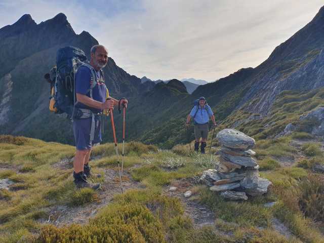
We left the car park at Trilobite Hut just before 12pm, hefting on heavy packs. It was a lovely day, not too hot, with a slight wind which kept things cool. We had a delightful walk up the valley, stopping at the restored Chaffey’s Hut for lunch. Chaffey’s is a small 4-bunk slab hut next to the river. It looked cosy inside, with the sleeping part closed off from the draughtier outer part of hut. The hut is next to a beautiful deep swimming hole in the River (which we didn’t dip into!).
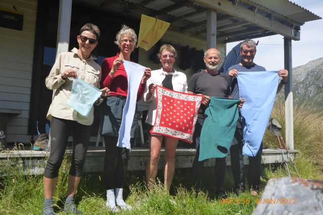
Esther, Jo, Maaike, Graeme and Bruce - the team. Photo at Boulder Lake hut...the size of our towels almost reflected the size of our packs
Tall, yellow-flowered Bulbinella was a frequent sight in the lower open parts of the valley, along with large bushes of white flowering hebe. Graceful, tall red tussock filled the open valley floor.
Higher up the valley we paused at the characterful Tent Camp – another restored hut, with a canvas tent hung inside. Historic remnants around the camp give it an authentic feel. We then passed by the small green Cobb Hut, near the turnoff to Cobb Lake (which is up and over a nearby moraine).
A highlight of the upper valley was seeing red flowering mistletoe along the track.
We arrived at Fenella Hut about 4.30pm. It was still warm, so we quickly dropped our packs (grabbing bed spots in the hut) and headed up to the tarn for a glorious swim in the deep, black rock pool. The water was surprisingly warm! It’s a stunning spot nestled below the rocky peak of Mt Zenicus.
We had decided earlier in the day to stay in the hut rather than heading up to the ridge to camp. The plan was to have an early start and fresh legs for the climb in the morning. A cold wind blew up overnight, so we were pleased to have been in the hut rather than camping. Plus, we all thoroughly enjoyed our swim in the gorgeous tarn.
Day Two – Fenella to Lonely Lake (31 Dec)
We left the hut about 8am and headed up the hill in the cool of the morning with heavy packs (carrying lots of water as there are no water sources along the ridge). It took an hour to climb up onto the ridge where we looked down on the hut and the tarn. We had a beautiful day for our walk along the tops to Lonely Lake, hardly any wind only a light cooling breeze. It was a demanding day with lots of steep ups and downs.
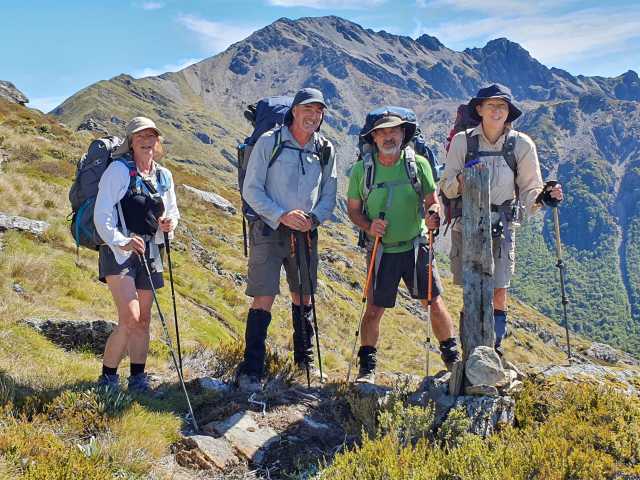
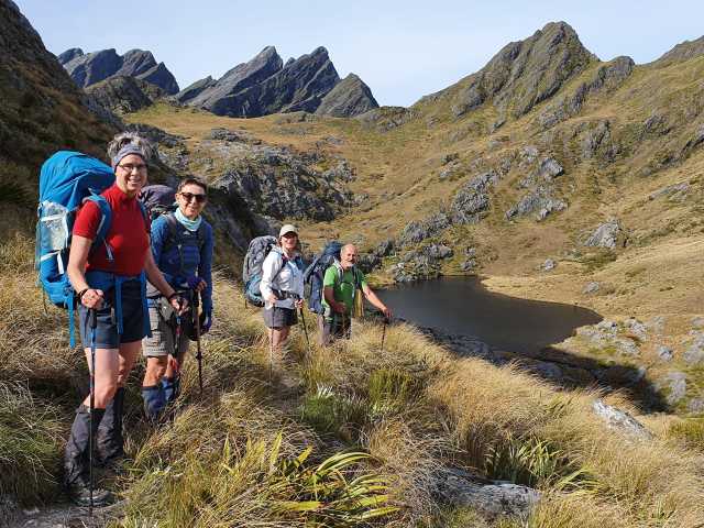
Photo-stop by an upright stone cairn, Kakapo Peak in the backgound: Maaike, Bruce, Graeme and Esther
We sidled around Waingaro Peak and across a small scree slope, then up the ridge that led to Kakapo Peak, climbing to the fork in the track which goes up to the top of the Peak. We sat and absorbed the views here (at 1600m) and decided they were good enough without climbing up to the top of Kakapo Peak! After a lunch stop, we continued on a sidle below Kakapo Peak and onto the large scree slope crossing. Luckily it was stable and didn’t give us any problems.
Further along the ridge we sidled left then right around two rocky tops (Pts 1512 and 1610). It was slow going, with little in the way of a track and very steep slopes. Some of us were getting pretty tired by then and taking care not to slip (or grab a spiky spaniard). After the sidles, we got onto a wooded rocky ridge that led us down to Lonely Lake. About 4pm we met two trampers on their way to Fenella – it seemed too late in the day to be headed there, but they were a lot younger than us. At that stage in the day our packs were feeling heavy and bodies a bit slow.
Lonely Lake hut was a bright yellow surprise, with a couple already inside the tiny two-bunk hut. The lake is nestled at the top of a series of glacial basins and finding camping spots in among the rocks proved slightly tricky. Maaike ended up dragging her tent to a less bumpy spot about 10pm! Jo and Esther went down to the lake for a wash (it was too muddy and shallow for a swim). Being New Year’s eve, Graeme shared a wee tot of fortified wine!
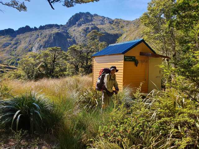
Lonely Lake hut
Day Three – Lonely Lake to Anatoki River (1 Jan)
We left the hut about 8.30am and headed up to the saddle below the Drunken Sailors. Another beautiful day! We had decided to camp down by the river that night instead of trying to get to Adelaide Tarn in one day.
The first part of the day was relatively easy, up onto the ridge and under the rocky Drunken Sailors. The first part of the route was easy to follow, then we scrabbled through tough scrub looking for the route just above the treeline. This led onto the ridge and the route down into the forest and valley below. We stopped for lunch in a smidge of shade just on the treeline and met a group of three coming up who stopped to chat and swap route tips.
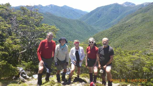
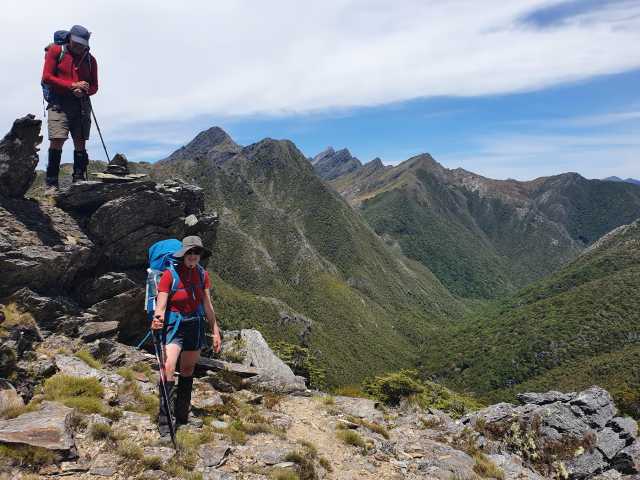
Bruce, Esther, Maaike, Jo, Graeme. Just before we dropped into the trees to go down to the Anatoki River
The first part of the route down through the trees was relatively easy to find, with regular cairns. Graeme thoughtfully added some pink tape to better mark the track. Towards the bottom third of the ridge we lost the cairns and veered off to the right, bush-bashing down to the river. The GPS files on Esther and Maaike’s phones (downloaded from Andrea’s trip two years ago) were very useful, although we came down slightly to the right of that line.
We crossed the river easily in the shallows and started upstream towards the camping spot at Pt 744. It was now around 5pm, so we felt it had been a good call to camp by the river. We met two families coming down the river who were already camped at 744, who said there was not much more room there. We went back downstream to a mossy glade under the trees, a perfect camp site. A bonus was a small plunge pool nearby in the river for a welcome wash.
Day Four – Anatoki River to Adelaide Tarn (2 Jan)
We woke up to beautiful birdsong, dry tents and another calm sunny day. We packed up and left just after 9am and headed up-river. Although the track was poorly defined, it was reasonably easy to follow with not too much bush-bashing. We ate lunch sitting on smooth rocks in the river. After lunch the route got a bit trickier with some skirting around large rocks and picking our way through old rock fall. As we moved up the river there was frequent checking against the GPS file to ensure we followed the correct tributary up towards Mt Douglas. Spotting footprints in the mud were reassuring indicators we were more or less in the right place.
We left the river slightly early to go up a spur on the advice of a couple who were in the hut at Lonely Lake. This ended up being quite tricky and time-consuming as there was no track at all. We had hoped to find cairns at the top leading to a sidle onto the ridge but didn’t find any. The hillside was very steep with lots of slippery dracophyllum. We ended up on a wee saddle on the ridge, south of Mt Douglas. Travel was slow, navigating past steep rock outcrops and through dense forest; morale got a bit low. Graeme was a steady leader and decided we should head back downhill to a slightly easier contour and then work our way around the hill to connect with the GPS route. We were all delighted to see a well-defined track (almost paved with rock!) leading up to the ridge. We were bang on the GPS route which was reassuring. The track popped us up, through and over a large rock onto the ridge above Adelaide Tarn. Massive relief!
On the saddle looking down into Adelaide Tarn, Dragon’s Teeth in the background
We were all pretty tired by this point (about 6pm) but felt jubilant looking down onto Adelaide Tarn. Looking back along the ridge we could see the looming jagged Dragon’s Teeth ridge which we had spent the last two days detouring down and under.
It was an easy walk down to the tarn and we found nice camp spots. There was a lovely rocky pool for a swim at the foot of a waterfall – heavenly! Swims each night were becoming a highlight of the trip.
It was a social evening. Esther met her ex-student Lara (and stayed in the hut) and Jo met Leigh, an ex-DOC workmate, and her partner.
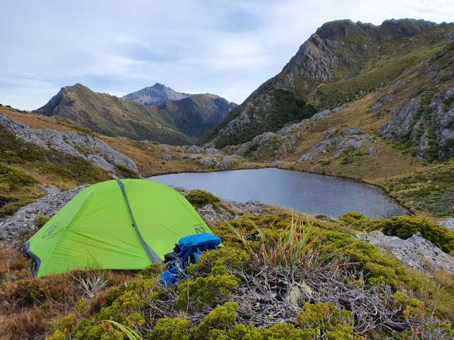
Adelaide Tarn
The NOBO group had left a message in the hut for us which we read with interest. One of their party, Rod, had been helicoptered out of Boulder Lake due to a heart condition. The note had instructions on where to find Graeme’s car and also advised us not to go out the Lead Hills route if it was wet as ‘the cairns were spasmodic & windfall in the bush + overgrown track ’. It had taken them a 10.5 hour climb from Quarz Range road to the Lead Hills flanks with a ‘dodgy sidle trail along 1300m contour to Lake Clara’ (where they had emergency camped).
Day Five – Adelaide Tarn to Boulder Lake (3 Jan)
We left Adelaide Tarn just after 9am – another glorious day, sunny and no wind. We moved steadily up the hillside to the Needles Eye, watched intently by a goat on an adjacent ridge.
Leaving Adelaide Tarn
The next bit of the route was along a rocky, sharp ridge – quite razorback in parts and requiring a bit of scrambling and ‘don’t look down’ moments for Jo and Maaike. Grippy rock with lots of great foot and hand-holds made the climbing easier. In the note from the NOBO group, Ray had described this part as a ‘relatively straightforward delightful ridgetop ramble’… we found it slow going, particularly in the more exposed parts. Close-up treats were tiny red sundew plants, rata and unusual lichens on trees. The views were amazing. We could see back over to the angular and jagged Dragon’s Teeth and our route over the last four days. We felt satisfied and proud of our journey so far.
'Relatively straightforward delightful ridgetop ramble....’
We took the next stage slowly, particularly the sidle under Pt 1450 towards Green Saddle. Looking out over Boulder Lake from the saddle, the landscape had quite a different character: grey, rocky Lead Hills to the left; a valley filled with tall red tussock and eroding & scree-covered mountains beyond the lake.
The track down the open spur into the valley was easy and we then picked our way through tunnels in the tussock towards the bush on the edge. Luckily it was dry underfoot. We moved into the trees for a bit until the bush got too thick and then pushed through vegetation on the edge to get to the hut.
The small stream beside the hut (Suspicion Creek) was lovely and clear, and we all enjoyed a wash. We had the hut overnight to ourselves. Around 7pm two fit and energetic young lads (Jamie and Oliver) appeared, travelling very light. They had come from Lonely Lake that morning, having left the Cobb Valley the day before. We were impressed and entertained by their stories. They left an hour or so later having eaten a tin of baked beans and crackers to overnight at Beatham’s Clearing before heading out the next day.
Day Six – Boulder Lake to Lake Clara (4 Jan)
We all enjoyed a relaxed morning at the hut; washing and drying clothes, chatting and sharing highlights of the trip. Jo and Esther had an early cold plunge in the waterfall pool.
After lunch and restoring fluid intakes we made our way round the edge of the lake and onto the rocky ridge leading to Lake Clara in the Lead Hills.
We camped at Lake Clara as we knew our last day out would be a long one. It was a beautiful spot and we all loved swimming in the lake. As it is enclosed by a rock amphitheatre, the lake has very little sediment. Luckily we had another calm evening for camping, although Bruce did move his tent away from a rock fall zone under the cliff.
While most of our camp spots that night were a bit uneven or on a lean, it was a delightful place to spend an evening enjoying the last warm sun of the day.
Day seven – Lake Clara to Quartz Range road end (5 Jan)
Even with an early start this proved to be a long day. Again we were lucky to have good weather. The sidle around the flanks of the Lead Hills was slow going, making our way from cairn to cairn and being reassured by orange blazed circles on some rocks that we were on the right route. Most of the marking seemed to be aimed at southbound trampers. It was steep and slow heading down the ridge and up and over Pt 1362. The rock forms were stunning.
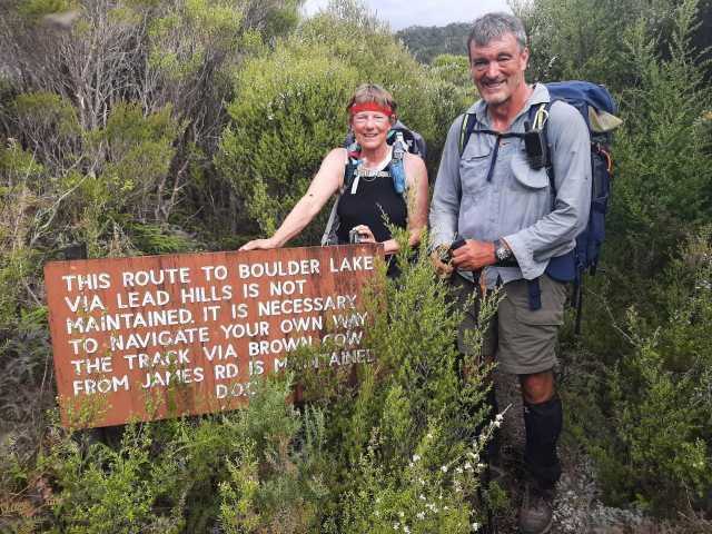
The track through the trees past Pt 920 was a bit overgrown but easy to follow. Then we hit the windfall, which involved an extra bit of dodging past a wasp nest in an upturned tree root. Finding our way onto the GPS route down the spur was difficult, so we headed downhill in generally the right direction. We finally ended up connecting up with the GPS route and then onto a defined track leading down into the valley. As the DOC sign at the bottom says, it is not maintained! At times this track appeared to follow an old water-race and there were deep guts at the side to avoid.
The End!
We got to the farm road about 6pm and Graeme and Esther headed off to pick up the car. Reaching the civilisation of Collingwood, we had dinner in the pub and shared reflections of our journey. We were all proud to have made it! Slow service in the pub meant we didn’t leave Collingwood until 9.30pm so we didn’t get back to Nelson until 11pm.
We all agreed the social aspect and team spirit was the absolute highlight of our trip. The overall tone of the trip was ‘slow and steady’ and ‘get there safely’. We were pleased to have completed our journey together and proud to have faced-up to fears and challenges along the way. All in all, it was seven glorious days in the hills with a great group of people.
Graeme Ferrier (trip leader), Esther Sassenburg, Jo Gould, Maaike von Hoeflaken, Bruce Thomas