Three trampers, hopeful that the high over the country would last, set out from the Hackett car park at 8.45am, for a five-day adventure. An easy walk up-river to the turn off to Mt Starveall, then a slow section as we negotiated crossing the river multiple times.
We had morning tea at the last of the river crossings before starting the steep incline. Lunch was in the vicinity of Parachute Rock, the first opportunity of a view out over the valley. A final steep pinch up to the hut, arriving at 3pm. A cool wind had picked up, but we kept warm making a concerted effort replenishing the but firewood pile. [6 hrs.]
Day 2
We set out in clear, sunny and warm conditions. We explored the summit of Mt Starveall (1511m) before descending steeply into beech forest to a saddle and sidle around the northern flank of Slaty Peak to Slaty Hut where we had a brew up and early lunch. We had seen the last of only two other people in five days, the TA hikers stopped coming through about 27th April.
From the hut we sidled to the ridge where we remained for two more days enjoying changing vistas to all directions, glimpsing Cape Campbell and the outline of the North Island. We walked in beech forest, briefly after grassy Ada Flat, had a long steep climb up to Old Man Peak, (1614m) then bounced up and down along the ridge until eventually reaching the turn off to Old Man Hut. We discussed the need to relocate this hut nearer the ridge line, but did admit that it was a nice grassy flat, albeit 200m below the ridge. [8.5hrs.]
Day 3
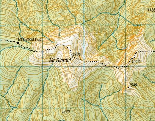
The inevitable 200m climb from the hut to the ridge, then up to Little Rintoul (1643m). We sheltered from a keen breeze and had morning tea before descending 250m down a rocky ridge and then scree to the saddle between the Rintouls. It was then a climb of 400m to Mt Rintoul, the highest point of our tramp at 1731m. The track between the Rintouls was steep and often on loose rock – slow and tricky.
We enjoyed the summit for an hour having lunch and taking in the expansive views. It was possible to see most of our route from Starveall. A further hour down a steep scree slope and steep section of bush brought us to Rintoul hut. [5 hrs.]
Information in Rintoul Hut about the route we’d taken: ‘Old Man Hut, 3km, 5 hours’ indicated the steepness and up and down nature of this section.
Rintoul Hut squats in a beautiful setting. It was sheltered and mild so afternoon activities included clothes washing and firewood chopping.
Day 4
We had decided that we would try to get to Mid Wairoa Hut today instead of stopping at Tarn Hut. It was a slow climb in beech forest to the saddle to Purple Top, then along a ridge towards Bishops Cap. A descent through beech forest till the turn off to Tarn Hut. [4 hrs.] We enjoyed lunch and lake views here. It was then a long sidle along the west flank of Bushy Top before reaching the Goulter Hut–Mid Wairoa Hut turnoff.
It was a lovely but steep descent to the river, the sunlight coming through mature beech trees.
We were in the habit of gathering firewood on our approaches to huts, but it proved tricky negotiating branches over and off the swing bridge, especially with a two-metre drop to the track from the bridge. [8 hrs.]
Our last night, Sue got a good fire going with the last piece of dry wood, the only hut on the route with an open fire.
Pat and Sue braved the cold of the Wairoa River for a quick dip.
Day 5
The walk out along the river to the car proved to be what everyone had said about it. Steep, tricky and slow in places. DOC had been in recently, clearing the track of windfall, but there had been further tree fall since. We arrived at the locked gate, just after the bike park, and were required to wait 30mins to be transported by a logging company vehicle the remaining 3km of road to our awaiting car. [5.5hrs.]
It was a great trip with plenty of challenges, great weather, beautiful vistas & great company.
Participants were:Sue Henley, Pat Holland, & Kath Ballantine (leader and scribe).