Six Trampers set off from the Hacket Car park at 08.30am. We walked for approx. 30 mins before taking an orange triangle marked, but not sign-posted track to the right. A steep ascent for 20 mins then the track levelled out and sidled around in mixed pine and scrub bush before we came out on a ridge between the Hacket and Serpentine valleys. Elevation 400m from 240m on Hacket track. An over-grown Forestry road comes up to this saddle from the Serpentine Valley at this saddle. The track left the ridge and followed a pack horse track sidling along the hillside down towards the mines and Hacket track. We were informed by track posters that this track was built to carry the Chromite down into the Serpentine Valley and out to Nelson. We were impressed by the stone work supporting the road which was built sometime in the 1860’s. We found 2 mine shafts in the area. Morning tea was at a picnic table above this track offering us views across the Hacket to Mt Malita. Waimea Tramping club cleared the first part of the loop track up to the saddle several years ago and until recently it was not well marked at the Hacket track turnoff, but it seems some effort has been put into this with the placing of orange markers along the track and with the appearance of the picnic table.

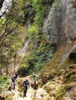
We returned to the Hacket track East of the Whispering Falls turnoff, and after a short walk turned off to the Falls. An easy river crossing and short walk to the base of the falls, then a slow amble up the falls admiring the bush, the colours in the creek, and taking photos, before we emerged to a grassy flat and another picnic table were we had lunch.
The return to the car park took approx. 1 hr. The day was cool and conductive to walking but not swimming so none of us took the opportunity to jump in the Hacket pools back at the car park.
Trip participants:
Kath Ballantine (leader & scribe), Mark Graesser, Philip Palmer and visitors: Richard Benfield, Christine Wanke, and Glenys Henry.
Leader: Kath Ballantine