BEGIN:VCALENDAR
VERSION:2.0
PRODID:-//jEvents 2.0 for Joomla//EN
CALSCALE:GREGORIAN
METHOD:PUBLISH
BEGIN:VEVENT
UID:480266f4ef38fa8b84d223f411dfa19f
CATEGORIES:Day Trip
CREATED:20250618T202833
SUMMARY:Fringed Hill Circuit
URL;VALUE=URI:https://live.nelsontrampingclub.org.nz/events/1532/fringed-hill-circuit?tmp
l=component
DESCRIPTION:This trip replaces the orignal plan to summit Gordon's Knob, due to the roa
d being closed and not likely to reopen any time soon.\nThis trip did not h
appen on the 27th, because my car would not start.\nScroll to end to see up
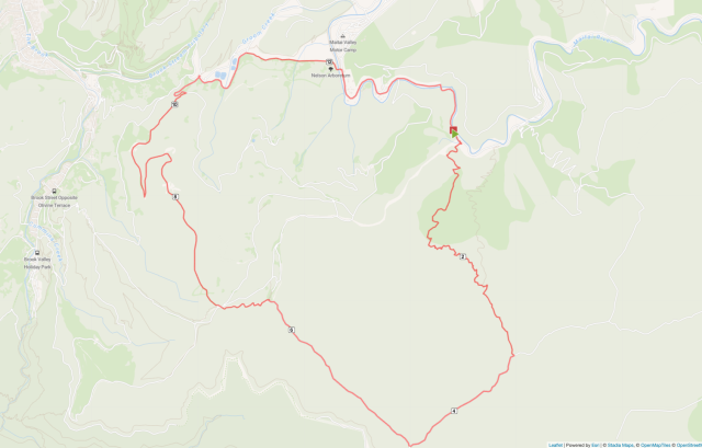
dates...\nComplete a circuit that starts and finishes in the Maitai Vally w
ith Fringed Hill the high point.\nStart in Maitai Valley and ascend the MTB
downhill track Maggies Farm and join another MTB track Whaimana.\nFollow t
his to Sunrise Ridge, then onto Black Diamond and follow this to Fringed Hi
ll.\nStart descent down Fringed Hill Road, then follow the unamed spur down
to Tantragree Saddle (I believe this starts as a track then changes into a
road.\nFrom Tantragree walk past the Rush Pools back into Maitai Valley an
d follow the road back to the start / cars.\nApprox 15km and 800m ascent wi
th all the ascent over the first 4.5km\n \nTo start with we'll be climbing
MTB downhill tracks, which I believe these are shared use.\nThese are not h
igh use tracks are we can reduce the chances of meeting bikes by starting e
arly.\n \nUpdate: I did a quick recce of the start and end points. The star
t is steep and narrow. The exit is a 4WD track / gravel road where it meets
Tantragee Saddle.\nI've set the grade as fit because it's a steep start an
d does really let up until the saddle. It also follows a mountain bike trac
k and we'll need to be on the look out for bikes.\nThat said this is a grad
e 7 track so probably not a high use track and we should hear them coming.\
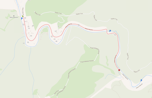
nThere is approximately 2km of road between the start and end points, so if
numbers allow we may want to park a car at each end.\nIf not we'll need to
choose between a road walk at the start or the end of the walk.\n \n\nPoss
ible parking spots and distance between start / finish (start is the red sq
uare)\n \n\n This event was imported from: https://live.nelsontrampingclub.
org.nz/events/1532/fringed-hill-circuit?tmpl=component
X-ALT-DESC;FMTTYPE=text/html:This trip repl
aces the orignal plan to summit Gordon's Knob, due to the road being closed
and not likely to reopen any time soon.
This trip did not happen on the 27th, because my
car would not start.
Scroll to end to see
updates...
Complete a circuit that starts and finishes in t
he Maitai Vally with Fringed Hill the high point.
Start in Maitai Val
ley and ascend the MTB downhill track Maggies Farm and joi
n another MTB track Whaimana.
Follow this to Sunrise Ridge, then onto Black Diamond and follo
w this to Fringed Hill.
Start descent down Fringed Hill Road, then fo
llow the unamed spur down to Tantragree Saddle (I believe this starts as a
track then changes into a road.
From Tantragree walk past the Ru
sh Pools back into Maitai Valley and follow the road back to the start / ca
rs.
Approx 15km and 800m as
cent with all the ascent over the first 4.5km
&n
bsp;
To start with we'll be climbing MTB downhill tracks, which I bel
ieve these are shared use.
These are not high use tracks are we can r
educe the chances of meeting bikes by starting early.
Update: I did a quick recce of the start and end points. The
start is steep and narrow. The exit is a 4WD track / gravel road where it
meets Tantragee Saddle.
I've set the grade as fit because it's a stee
p start and does really let up until the saddle. It also follows a mountain
bike track and we'll need to be on the look out for bikes.
That said
this is a grade 7 track so probably not a high use track and we should hea
r them coming.
There is approximately 2km of road between the start a
nd end points, so if numbers allow we may want to park a car at each end.
If not we'll need to choose between a road walk at the start or the en
d of the walk.
Possible p
arking spots and distance between start / finish (start is the red square)<
/p>
This
event was imported from: https://live.nelsontrampingclub.org.nz/events/1532
/fringed-hill-circuit?tmpl=componentDTSTAMP:20260610T142940
DTSTART;VALUE=DATE:20250803
DTEND;VALUE=DATE:20250804
SEQUENCE:0
TRANSP:OPAQUE
END:VEVENT
END:VCALENDAR