
This trip repl aces the orignal plan to summit Gordon's Knob, due to the road being closed and not likely to reopen any time soon.
This trip did not happen on the 27th, because my car would not start.
Scroll to end to see updates...
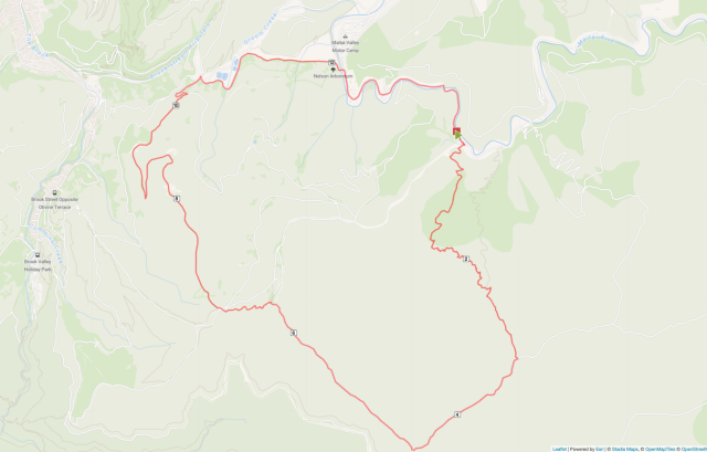
Complete a circuit that starts and finishes in t he Maitai Vally with Fringed Hill the high point.
Start in Maitai Val ley and ascend the MTB downhill track Maggies Farm and joi n another MTB track Whaimana.
Follow this to Sunrise Ridge, then onto Black Diamond and follo w this to Fringed Hill.
Start descent down Fringed Hill Road, then fo llow the unamed spur down to Tantragree Saddle (I believe this starts as a track then changes into a road.
From Tantragree walk past the Ru sh Pools back into Maitai Valley and follow the road back to the start / ca rs.
Approx 15km and 800m as cent with all the ascent over the first 4.5km
&n bsp;
To start with we'll be climbing MTB downhill tracks, which I bel ieve these are shared use.
These are not high use tracks are we can r educe the chances of meeting bikes by starting early.
Update: I did a quick recce of the start and end points. The
start is steep and narrow. The exit is a 4WD track / gravel road where it
meets Tantragee Saddle.
I've set the grade as fit because it's a stee p start and does really let up until the saddle. It also follows a mountain bike track and we'll need to be on the look out for bikes.
That said this is a grade 7 track so probably not a high use track and we should hea r them coming.
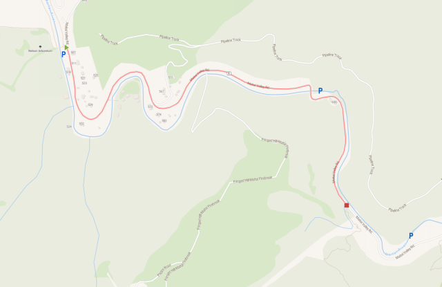
There is approximately 2km of road between the start a nd end points, so if numbers allow we may want to park a car at each end.
If not we'll need to choose between a road walk at the start or the en d of the walk.
Possible parking spots and distance between start / finish (start is the red square)

| Trip Leader : | Rich Field |
| P hone : | 02102244767\n |
| Email : | < td>|
| Area : | Nelson\n |
| Panic Date : | 27- 07-2025\n |
| Planned Route : | Start in Maitai Valley and ascend the MTB downhill track Maggies Farm and join anoth er MTB track Whaimana.Follow this to Sunrise Ridge, then onto Black Diamond and follow this to Fringed Hill.Start descent down Fringed Hill Road, then follow the unamed spur down to Tantragree Saddle (I believe this starts as a track then changes into a road.From Tantragree walk past the Rush Pools back into Maitai Valley and follow the road back to the start / cars.\n |
| Locator Beacon/s : | Beacon #7\n |
| Grading : | Select an appropriate grade for the hardest day on your Trip.\n |
| Grade : | Fit\n |
| Cost : | The travel distan ces are used to calculate the cost of a trip. The trip co-ordinator will co mplete these values. However, if you know the values, for example by using Google Maps, then by all means complete. Make sure the values (double to in clude return journey) are correct to be fair to the drivers and participant s. IMPORTANT: The rate table needs to have a month and year value for cents /kilometre. Trip coordinator is responsible to entering this information.\n |
| Cost $ : | 2\n |
| Sealed km (Enter the number of kms travelled on sealed roads to/f rom the trip) : | 0\n |
| Unsealed km (En ter the number of kms travelled on unsealed roads to/from trip.) : | 0\n |
| Signoff : | Default is Programme , please set the Status to either 'Completed' or 'Cancelled' when appropria te. Also enter the number of Visitor and Total numbers on your trip. Thanks . NOTE: When the status is Completed or Cancelled the event WON'T appear on the Home page calendars.\n |
| Event Status : < /td> | Completed\n |
| Visitors : | 0\n< /td> |
| Total : | 2\n |
This trip repl aces the orignal plan to summit Gordon's Knob, due to the road being closed and not likely to reopen any time soon.
This trip did not happen on the 27th, because my car would not start.
Scroll to end to see updates...
Complete a circuit that starts and finishes in t he Maitai Vally with Fringed Hill the high point.
Start in Maitai Val ley and ascend the MTB downhill track Maggies Farm and joi n another MTB track Whaimana.
Follow this to Sunrise Ridge, then onto Black Diamond and follo w this to Fringed Hill.
Start descent down Fringed Hill Road, then fo llow the unamed spur down to Tantragree Saddle (I believe this starts as a track then changes into a road.
From Tantragree walk past the Ru sh Pools back into Maitai Valley and follow the road back to the start / ca rs.
Approx 15km and 800m as cent with all the ascent over the first 4.5km
&n bsp;
To start with we'll be climbing MTB downhill tracks, which I bel ieve these are shared use.
These are not high use tracks are we can r educe the chances of meeting bikes by starting early.
Update: I did a quick recce of the start and end points. The
start is steep and narrow. The exit is a 4WD track / gravel road where it
meets Tantragee Saddle.
I've set the grade as fit because it's a stee p start and does really let up until the saddle. It also follows a mountain bike track and we'll need to be on the look out for bikes.
That said this is a grade 7 track so probably not a high use track and we should hea r them coming.
There is approximately 2km of road between the start a nd end points, so if numbers allow we may want to park a car at each end.
If not we'll need to choose between a road walk at the start or the en d of the walk.
Possible p arking spots and distance between start / finish (start is the red square)< /p>
| Trip Leader : | Rich Field |
| Phone : | 02102244767\n |
| Email : | |
| Are a : | Nelson\n |
| Panic Date : | 27-07-2025\n |
| Planned Route : | Start in Maitai Valley and ascend the MTB downhill track Maggies Farm and join an other MTB track Whaimana.Follow this to Sunrise Ridge, then onto Black Diam ond and follow this to Fringed Hill.Start descent down Fringed Hill Road, t hen follow the unamed spur down to Tantragree Saddle (I believe this starts as a track then changes into a road.From Tantragree walk past the Rush Poo ls back into Maitai Valley and follow the road back to the start / cars.\n< /td> |
| Locator Beacon/s : | Beacon #7\n |
| Grading : | Select an appropriate grade f or the hardest day on your Trip.\n |
| Grade : < /td> | Fit\n |
| Cost : | The travel dis tances are used to calculate the cost of a trip. The trip co-ordinator will complete these values. However, if you know the values, for example by usi ng Google Maps, then by all means complete. Make sure the values (double to include return journey) are correct to be fair to the drivers and particip ants. IMPORTANT: The rate table needs to have a month and year value for ce nts/kilometre. Trip coordinator is responsible to entering this information .\n |
| Cost $ : | 2\n |
| Sealed km (Enter the number of kms travelled on sealed roads t o/from the trip) : | 0\n |
| Unsealed km (Enter the number of kms travelled on unsealed roads to/from trip.) : | 0\n |
| Signoff : | Default is Progra mme, please set the Status to either 'Completed' or 'Cancelled' when approp riate. Also enter the number of Visitor and Total numbers on your trip. Tha nks. NOTE: When the status is Completed or Cancelled the event WON'T appear on the Home page calendars.\n |
| Event Status : | Completed\n |
| Visitors : | 0 \n |
| Total : | 2\n |